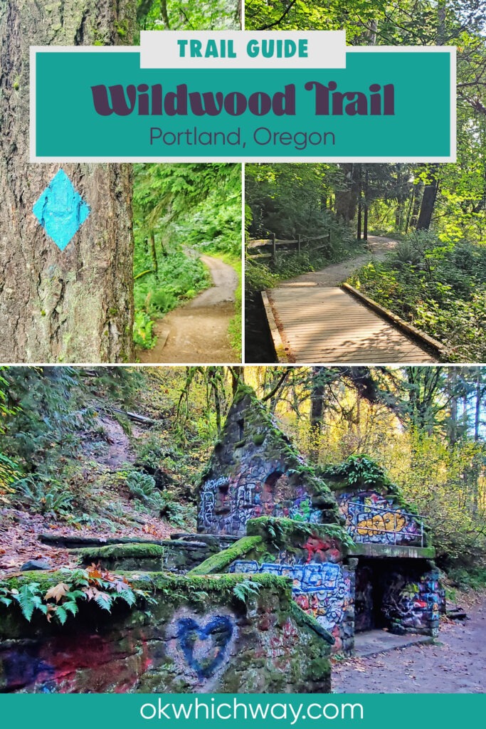
Wildwood Trail Guide
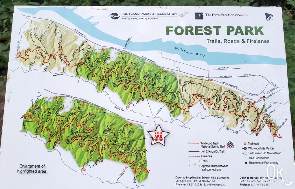
Hiking has always been my way of unplugging, and after years of exploring the trails of Forest Park, I set a goal last summer to walk all 30.2 miles of the Wildwood Trail from end to end. While the first three miles are located in Washington Park, the remainder of the trail stretches through Forest Park along the eastern slope of the Tualatin Mountains. With over 80 miles of trails and 40 different access points, this urban forest is a massive local treasure.
This post may contain affiliate links. When you make a purchase using one of these affiliate links, we get paid a small commission at no extra cost to you.
This guide breaks down the trail section by section. Whether you plan to hike the entire trail or create a shorter loop by incorporating intersecting paths, you will find that the signage is generally good. However, with so many trails crossing through the woods, it’s important to stay aware of your direction at every junction.
Wildwood Trail Stats
Trailheads: Multiple trailheads from Washington Park to Newberry Road
Trail Type: Point to Point
Difficulty: Varies from ⚪ Easy to ⟡ Challenging, depending on the distance of your hike, based on OK Which Way’s rating system
Distance: 30.2 miles
Elevation: varies from 300 feet at the Witch’s Castle to 950 feet at Pittock Mansion
Planning Your Visit
Location: Washington Park & Forest Park in Portland, Oregon
Time Zone: Pacific Standard Time
Hours: 5am – 10pm Daily
Seasonal Closures: None
Parking: Multiple parking locations
Park Pass Needed: None
Entrance Fee: No entrance fee for walking on Wildwood. However, Washington Park does have a parking fee.
Trail Map: Link to AllTrails map
Trail Use: There are trails within Forest Park suitable for bikes and horses, but Wildwood is pedestrian only.
Trail Closures: Check the city of Portland website for current closures in Forest Park
Cell Phone Coverage: Although the park is in a big city, cell service is spotty
Pets: Dogs are welcome on a leash
FUN FACT: At over 5,200 acres, Forest Park is one of the largest urban forest reserves in the United States. It is roughly six times the size of New York’s Central Park and stretches for more than 7 miles along Portland’s West Hills.
Wildwood Through the Seasons
The experience on Wildwood changes dramatically depending on when you visit. While the canopy provides some protection, you’ll want to prepare for the specific trail conditions and natural shifts of each season.
Spring: Although there are dry days, be prepared for muddy trails. This is the best time to see Trillium, Wood Anemones, and Yellow Violets blooming along the forest floor.
Summer: The trail is dry, busy, and at its most vibrant with fully unfurled ferns and dense foliage. Look for Red Columbine and Oceanspray in bloom.
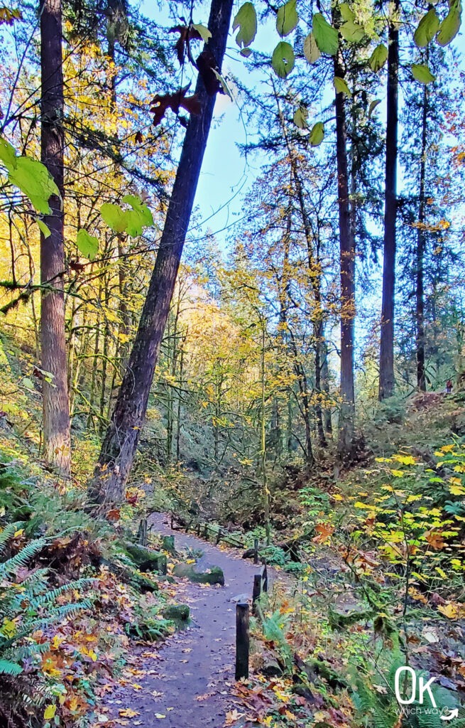
Fall: Bigleaf maples provide heavy leaf cover and gold tones. Rain returns during this season, making the trail wet. It is the peak time for fungi, including Chanterelles, Turkey Tail, and various shelf mushrooms on fallen logs.
Winter: Most leaves have dropped, opening up views through the bare branches. The trail is often muddy with occasional patches of ice or light snow. Hiking shoes with good traction are ideal to navigate the slick terrain.
HIKING THE WILDWOOD TRAIL
While Forest Park is home to many incredible paths, Wildwood is the only one that travels the entire length of the park from south to north. Most visitors choose to explore Wildwood by creating smaller loops with intersecting trails, but seeing the whole thing end to end is a special experience. In this section, I’m highlighting the most popular trailheads for reaching Wildwood so you can plan your visit, whether you are looking for a quick morning stroll or a longer adventure.
Wildwood Wayfinding
The signage throughout Forest Park is generally excellent, making it easy to navigate the dense forest.
You Are Here: Throughout Forest Park, you will find maps with “You Are Here” markers to help you track your progress.
Directional Signage: At most intersections, you will find signs pointing the way to specific landmarks and trails.
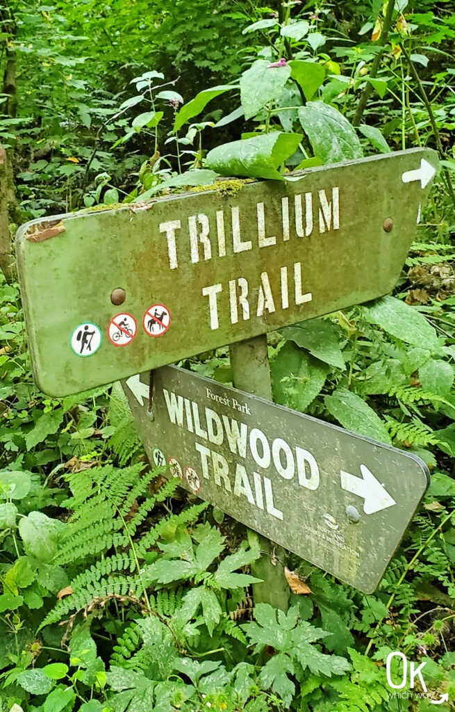
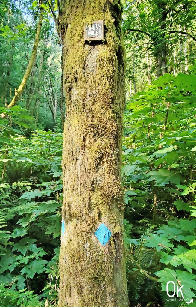
Blue Diamonds: Blue diamond stencils on trees every quarter mile along Wildwood confirm you are on the right path. Some trees also have additional markers displaying the specific mileage, which begins at 0 in Washington Park and ends at 30.2 at Newberry Road.
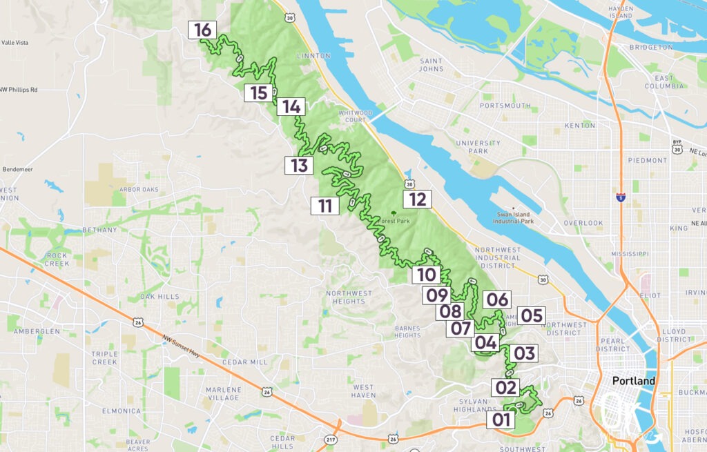
Trailheads: Use the numbered pins on this map for an approximate location of each trailhead mentioned in this guide.
Wildwood Southern Section: Miles 0 – 6
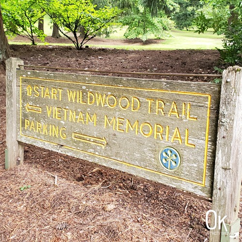
This section begins at Mile 0 near the Vietnam Veterans Memorial by the Oregon Zoo. The first few miles wind through Washington Park and Hoyt Arboretum.

Key Highlights
-
Redwood Deck: A viewing platform within Hoyt Arobretum in an area that features all three species of Redwood. Keep an eye out for the Dawn Redwood, the official Oregon state fossil. It was once thought to be extinct until living trees were found in China in the 1940s.
-
Barbara Walker Crossing: A pedestrian bridge at Mile 3 that leads you over the traffic on Burnside.
-
Pittock Mansion: The mansion was constructed in the early 1900s and is located at the highest point on the trail. Behind the mansion is a breathtaking view of the city.
-
Witch’s Castle: The famous stone ruins of a 1930s rest station. Please note: on the trail, follow the signs to the Stone House to reach the Witch’s Castle.
Washington Park Trailhead (01)
Wildwood Access Point: Mile 0
Parking: There are several ways to access the trailhead in Washington Park. The most convenient parking lot is directly across from the Vietnam Veterans Memorial on Knights Blvd, near the turn to Kingston Dr. If that lot is full, there are several larger lots closer to the Oregon Zoo that work well. For those skipping the car, TriMet bus stops are nearby, and the Washington Park MAX Station is just a short walk from the start of the trail.
Parking Fee: The parking lots within Washington Park are Pay to Park, check the city of Portland’s website for more information
Restrooms: Restrooms are near the max station
Directions from Parking to Trail: From the parking lot nearest to Kingston Drive, walk across Knights Boulevard to find the trailhead.
Other Notable Trails: The paved trail trough Vietnam Veterans Memorial is nearby. Also, this is the starting point of the 5+ mile Marquam Trail that heads to Council Crest. Marquam Trail is also part of the 4T Trail.
Hoyt Arboretum (02)
Wildwood Access Point: Mile .5 – 2.8, depending on which trail used to reach Wildwood
Parking: There is a parking lot off Fairview Blvd at the Hoyt Arboretum Visitor Center.
Parking Fee: The parking lot at Hoyt Arboretum is Pay to Park, check the city of Portland’s website for more information
Restrooms: Restrooms available at the visitor center
Directions from Parking to Trail: Several trails within Hoyt Arboretum provide access to the Wildwood Trail. At the southern end of the parking lot, both the Holly Trail and Overlook Trail offer the quickest routes, reaching Wildwood at approximately mile 0.5. Another option is taking the Beech Trail toward the Winter Garden to connect with Wildwood at roughly mile 2.2. You can also cross Fairview Blvd and follow the Redwood Trail to reach Wildwood at about mile 2.7.
Other Notable Trails: There are a number of trails meandering through Hoyt Arboretum. I haven’t been on one I don’t like. A popular one is the Redwood Trail to enjoy a view from the Redwood Deck.
Pittock Mansion (03)
Wildwood Access Point: Mile 3.7
Parking: Parking lot located at Pittock Mansion
Parking Fee: The parking lot at Pittock Mansion is Pay to Park, check the city of Portland’s website for more information
Restrooms: Restrooms are located in The Garage, near the museum store
Directions from Parking to Trail: Wildwood is at the west end of the parking lot. This is the opposite direction from the mansion.
Upper Macleay Park (04)
Wildwood Access Point: Mile 4.9
Parking: The parking lot is off Cornell Road, on the north side. If the lot is full, there is also street parking.
Parking Fee: There are no parking fees within Forest Park
Restrooms: Porta potty in the parking lot
Directions from Parking to Trail: Wildwood Trail access is at the parking lot. From the parking lot, facing the trail, head to the left if you want to go to Balch Creek and Witch’s Castle. Follow the trail to the right and cross Cornell if you want to go towards Pittock Mansion.
Other Notable Trails: Jay Trail behind the Bird Alliance of Oregon buildings
Lower Macleay Park [via Hwy 30] (05)
Wildwood Access Point: Mile 5.4
Parking: Follow NW Upshur Street to the round about with parking. If those spots are full, park along the street.
Parking Fee: There are no parking fees within Forest Park
Restrooms: Restrooms near the parking lot
Directions from Parking to Trail: Find the Lower Macleay Trail at the south end of the round about. You will walk under the Thurman Street Bridge, then follow the trail for about .8 miles until reaching the Witch’s Castle and intersecting with Wildwood.
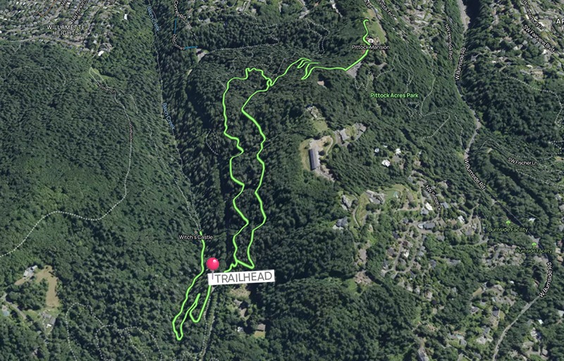
Recommended Short Hike Option
Experience Wildwood without hiking 30 miles
3.3 miles | 679 feet elevation gain
Starting at the Upper Macleay Trailhead, this hike connects two of the most iconic landmarks in the southern section of Forest Park. You will first head down the trail to the stone ruins of the Witch’s Castle before turning back to begin the steady climb to Pittock Mansion. Reaching the mansion rewards you with panoramic views of the city before you return to the trailhead.
Wildwood Middle Section: Miles 6 – 18
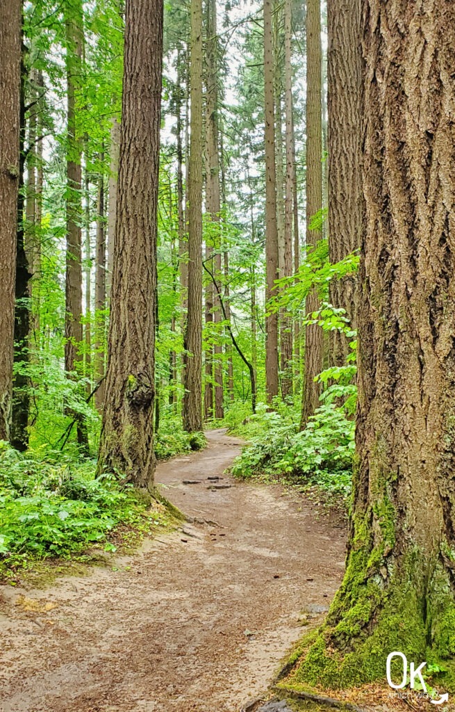
This middle stretch of Wildwood shifts from the high traffic landmarks into the heart of the forest. The trail intersects with other major park arteries like Leif Erikson Drive, Saltzman Road, and several Firelanes. It is here that you begin to feel the massive scale of the park as the path winds through quiet, fern filled canyons.
Key Highlights
-
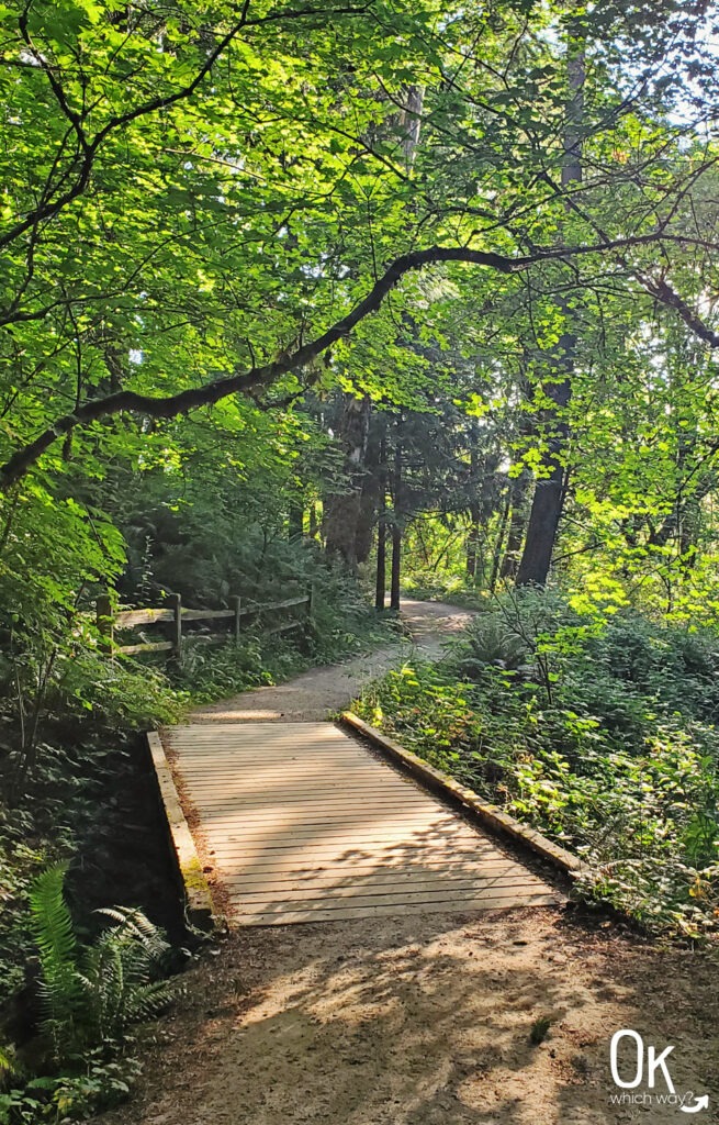
Footbridges: You will cross numerous wooden bridges that guide you over small dips in the terrain. These steady crossings help navigate the natural drainage points of the forest without steep descents or climbs.
-
The Rollercoaster: The elevation here is a series of steady ups and downs. It is rarely exceptionally steep, but the cumulative gain adds up as you wind through the heart of the park.
Thurman | Leif Erikson [via Hwy 30] (06)
Wildwood Access Point: Mile 7.8
Parking: Limited parking area near the trailhead
Parking Fee: There are no parking fees within Forest Park
Restrooms: Porta potty along the trail to Wildwood
Directions from Parking to Trail: Follow Leif Erikson until reaching the Wild Cherry Trail. Follow Wild Cherry to Wildwood.
Other Notable Trails: The Thurman Street Trailhead marks the southern end of the Leif Erikson Trail. You could walk its entire length to the Germantown Trailhead.
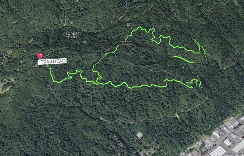
NW 53rd | Birch Trail | Holman Lane (07)
Wildwood Access Point: Mile 7.4
Parking: Parking directly off NW 53rd Drive, on the SW side.
Parking Fee: There are no parking fees within Forest Park
Restrooms: None
Directions from Parking to Trail: From the parking area, cross NW 53rd, and follow the Birch Trail less than a quarter mile to Wildwood.
NW 53rd | Dogwood Trail | Wild Cherry Trail (08)
Wildwood Access Point: Mile 7.8 – 9.2, depending on which trail used to reach Wildwood
Parking: Parking directly off NW 53rd Drive, on the east side.
Parking Fee: There are no parking fees within Forest Park
Restrooms: None
Directions from Parking to Trail: This trailhead has multiple trail options to reach Wildwood. Heading to the east along the Wild Cherry Trail will put you at Wildwood about mile 7.8. Going north on the Dogwood Trail will intersect Wildwood at mile 8.4. And, taking Keil to the west places you at Wildwood around mile 9.2.
NW 53rd (09)
Wildwood Access Point: Mile 9.2
Parking: Street parking available on both sides of NW 53rd.
Parking Fee: There are no parking fees within Forest Park
Restrooms: None
Directions from Parking to Trail: Wildwood is close to the north side of 53rd.
Forest Lane | Firelane 1 (10)
Wildwood Access Point: Mile 10.6 or 11.1
Parking: Street parking near the gate on Forest Lane
Parking Fee: There are no parking fees within Forest Park
Restrooms: None
Directions from Parking to Trail: Firelane 1 begins right after going around the gate at the end of Forest Lane. From there you have the option to walk along the fire lane until reaching Wildwood at about mile 11.1. Or, you could veer off the fire lane onto Morak and hit Wildwood at mile 10.6.
Upper Saltzman Rd | Firelane 5 (11)
Wildwood Access Point: Mile 15.8 or 16.6
Parking: From Skyline Blvd, turn onto NW Saltzman Road. Street parking is available near the gate.
Parking Fee: There are no parking fees within Forest Park
Restrooms: Porta potty near the trailhead
Directions from Parking to Trail: From this parking area you can choose to follow Saltzman and intersect with Wildwood around mile 15.8 or head towards the left on Firelane 5 and reach Wildwood around mile 16.6.
Lower Saltzman [via Hwy 30] (12)
Wildwood Access Point: Mile 15.4, as well as many other options
Parking: From Highway 30 turn onto NW Saltzman Road. Street parking is available at the trailhead.
Parking Fee: There are no parking fees within Forest Park
Restrooms: None
Directions from Parking to Trail: This trailhead has many avenues for connecting with Wildwood. The most direct route is taking Firelane 4, then turn right when reaching Leif Erikson. When getting to the Cleator Trail, take that and follow it up to Wildwood.
Other Notable Trails: If you plan ahead, transportation wise, you could walk from the Lower Saltzman Trailhead to the Upper Saltzman Trailhead. Another nice route is the Maple Trail.
Recommended Short Hike Option
Experience Wildwood without hiking 30 miles
4.3 miles | 548 feet elevation gain
Starting at the 53rd & Birch Trailhead, follow the Birch Trail to the Wildwood Trail before transitioning to the wide, gravel surface of Leif Erikson Drive. The route uses a series of shorter connectors, including the Alder, Keil, Dogwood, and Wild Cherry trails, to navigate the forest’s steady climbs and descents before returning you to your starting point.
Wildwood Northern Section: Miles 18 – 30.2
The northern section is less crowded than the southern end, and you are more likely to encounter trail runners or solo hikers rather than families out for a casual stroll. The dense canopy continues here and the trail is narrow as it winds toward the end of the 30.2 mile journey.
Key Highlights
-
Continuous Canopy: This section is defined by a deep, unbroken overhead cover of Douglas fir and Western hemlock. The dense foliage filters the sunlight and creates a quiet, immersive atmosphere.
-
The Terminus: The trail officially ends at the Newberry Road trailhead. There’s no fanfare – just a simple marker and the satisfaction of knowing you’ve finished.
Upper Springville Road (13)
Wildwood Access Point: Mile 18.4 – 22.3
Parking: From Skyline Blvd, turn onto NW Springville Road. A parking lot is near the gate.
Parking Fee: There are no parking fees within Forest Park
Restrooms: Porta potty near the gate
Directions from Parking to Trail: There are multiple trails to reach Wildwood from this trailhead. Walk around the gate to begin your hike.
Other Notable Trails: Ridge Trail, which takes you to a viewpoint of the St. John’s Bridge
Germantown Road (14)
Wildwood Access Point: Mile 24.4
Parking: At this trailhead there is parking on both sides of NW Germantown Road. If no parking is available here, the Germantown Trailhead at Leif Erikson is nearby (and has a porta potty.)
Parking Fee: There are no parking fees within Forest Park
Restrooms: None
Directions from Parking to Trail: The Wildwood Trail is near the parking areas.
Other Notable Trails: Cannon Trail to Leif Erikson
Newton Road (15)
Wildwood Access Point: Mile 25.3
Parking: From Skyline Blvd, turn onto Newton. Follow Newton for about a third of a mile to reach the parking lot.
Parking Fee: There are no parking fees within Forest Park
Restrooms: Porta potty in the parking lot
Directions from Parking to Trail: Take the connector trail from the parking lot to Wildwood.
Other Notable Trails: Newton Road and Firelane 10
Newberry Trailhead (16)
Wildwood Access Point: Mile 30.2
Parking: Street parking along NW Newberry Road
Parking Fee: There are no parking fees within Forest Park
Restrooms: None
Directions from Parking to Trail: The trailhead is on the SE side of Newberry.
Wildlife on the Trail
Forest Park is home to over 60 mammal species, including deer and coyotes. While sightings of larger animals are rare, I have spotted bear scat along the trail. You are most likely to encounter smaller critters and birds. A very common sight on the trail is the Pacific Banana Slug, an iconic PNW gastropod that grows up to ten inches long and helps the ecosystem by spreading mushroom spores.

FUN FACT: Laika Studios, based in Hillsboro, is releasing a stop-motion film titled Wildwood in October 2026. The movie is based on the Wildwood Chronicles book series by Colin Meloy, which reimagines this very forest as a magical wilderness.
Final Thoughts
Completing the Wildwood Trail in its entirety changed how I view Forest Park. It is easy to get used to the iconic views at Pittock Mansion and the convenience of the southern trailheads, but walking the full 30.2 miles gives you a real sense of the scale of this land. Whether you take it on in sections over a season or aim for a long distance day hike, there is deep satisfaction in reaching that simple marker at Newberry Road. It’s a reminder that we have a world class wilderness right in our backyard, and it’s available to those willing to follow the blue diamonds.
LEAVE NO TRACE
Optional Items to Bring
Visitor Information
Where to Eat
Since the Wildwood Trail is primarily situated within a 5,000 acre wilderness, you won’t find food options once you are in the woods. Plan to grab a bite before you head out or stop at one of these local favorites when you finish your hike:
- Elephants Delicatessen, ideal for grabbing deli sandwiches or prepared snacks near the southern end of the trail
- Wonderwood Springs, a whimsical cafe in St. Johns perfect for a coffee or light bite
- Lighthouse Restaurant and Bar, a classic neighborhood spot along Highway 30 that serves hearty burgers and comfort food near the Linnton area
- McMenamins Rock Creek Tavern, great for a sit down pub meal housed in a historic building near the northern section of Forest Park
Places to Stay
There are no lodging or camping options directly on the trail. You will want to book a stay in one of the surrounding neighborhoods or nearby cities to serve as your base camp. Here are a few recommended options:
- Hotel deLuxe, located in the Goose Hollow neighborhood and just minutes away from the Mile 0 trailhead in Washington Park
- St. Johns Inn, boutique historic inn is situated just across the St. Johns Bridge
- Home2 Suites in Hillsboro, if you prefer a suite with more space and a kitchenette, this is a great suburban option located off the sunset corridor.

Thinking About Hiking the Wildwood Trail?
Pin This to Help Plan Your Trip ⬇
Places to Explore Nearby
This trail review is based only on Jennifer’s experience. Hike at your own risk with the understanding that individual scenarios in a natural environment will be variable.